

metadata
license: etalab-2.0
tags:
  - semantic segmentation
  - pytorch
  - landcover
model-index:
  - name: FLAIR-HUB_LC-G_utae
    results:
      - task:
          type: semantic-segmentation
        dataset:
          name: IGNF/FLAIR-HUB/
          type: earth-observation-dataset
        metrics:
          - name: mIoU
            type: mIoU
            value: 34.239
          - name: Overall Accuracy
            type: OA
            value: 57.826
          - name: IoU building
            type: IoU
            value: 34.908
          - name: IoU greenhouse
            type: IoU
            value: 0
          - name: IoU swimming pool
            type: IoU
            value: 61.59
          - name: IoU impervious surface
            type: IoU
            value: 38.267
          - name: IoU pervious surface
            type: IoU
            value: 27.432
          - name: IoU bare soil
            type: IoU
            value: 33.594
          - name: IoU water
            type: IoU
            value: 65.32
          - name: IoU snow
            type: IoU
            value: 67.543
          - name: IoU herbaceous vegetation
            type: IoU
            value: 34.435
          - name: IoU agricultural land
            type: IoU
            value: 42.083
          - name: IoU plowed land
            type: IoU
            value: 10.228
          - name: IoU vineyard
            type: IoU
            value: 41.105
          - name: IoU deciduous
            type: IoU
            value: 55.992
          - name: IoU coniferous
            type: IoU
            value: 48.219
          - name: IoU brushwood
            type: IoU
            value: 14.462
pipeline_tag: image-segmentation
🌐 FLAIR-HUB Model Collection
- Trained on: FLAIR-HUB dataset 🔗
- Available modalities: Aerial images, SPOT images, Topographic info, Sentinel-2 yearly time-series, Sentinel-1 yearly time-series, Historical aerial images
- Encoders: ConvNeXTV2, Swin (Tiny, Small, Base, Large)
- Decoders: UNet, UPerNet
- Tasks: Land-cover mapping (LC), Crop-type mapping (LPIS)
- Class nomenclature: 15 classes for LC, 23 classes for LPIS
🔍 Model: FLAIR-HUB_LC-G_utae
- Encoder: UTAE
- Decoder: UTAE
- Metrics:
- Params.: 0.9
General Informations
- Contact: [email protected]
- Code repository: https://github.com/IGNF/FLAIR-HUB
- Paper: https://arxiv.org/abs/2506.07080
- Project Page https://ignf.github.io/FLAIR/FLAIR-HUB/flairhub
- Developed by: IGN
- Compute infrastructure:
- software: python, pytorch-lightning
- hardware: HPC/AI resources provided by GENCI-IDRIS
- License: Etalab 2.0
Training Config Hyperparameters
- Model architecture: UTAE
- Optimizer: AdamW (betas=[0.9, 0.999], weight_decay=0.01)
- Learning rate: 5e-5
- Scheduler: one_cycle_lr (warmup_fraction=0.2)
- Epochs: 150
- Batch size: 5
- Seed: 2025
- Early stopping: patience 20, monitor val_miou (mode=max)
- Class weights:
    - default: 1.0
    - masked classes: [clear cut, ligneous, mixed, other] → weight = 0
- Input channels:
    - SENTINEL2_TS : [1,2,3,4,5,6,7,8,9,10]
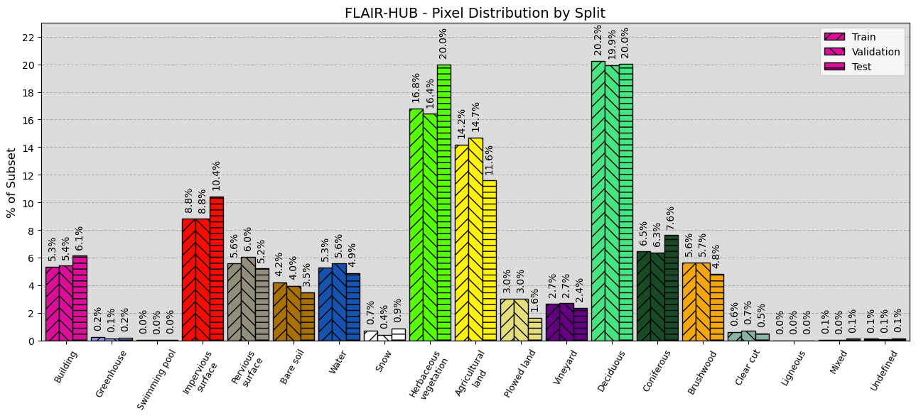
Training Data
- Train patches: 152225
- Validation patches: 38175
- Test patches: 50700
Training Logging
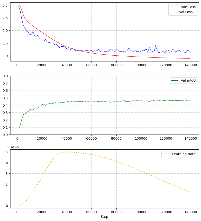
Metrics
| Metric | Value |
|---|---|
| mIoU | 34.24% |
| Overall Accuracy | 57.83% |
| F-score | 47.30% |
| Precision | 48.12% |
| Recall | 47.59% |
| Class | IoU (%) | F-score (%) | Precision (%) | Recall (%) |
|---|---|---|---|---|
| building | 34.91 | 51.75 | 54.37 | 49.37 |
| greenhouse | 0.00 | 0.00 | 0.00 | 0.00 |
| swimming pool | 0.00 | 0.00 | 0.00 | 0.00 |
| impervious surface | 38.27 | 55.35 | 51.43 | 59.92 |
| pervious surface | 27.43 | 43.05 | 51.24 | 37.12 |
| bare soil | 33.59 | 50.29 | 56.33 | 45.42 |
| water | 65.32 | 79.02 | 71.19 | 88.79 |
| snow | 67.54 | 80.63 | 69.71 | 95.61 |
| herbaceous vegetation | 34.44 | 51.23 | 51.81 | 50.66 |
| agricultural land | 42.08 | 59.24 | 57.01 | 61.65 |
| plowed land | 10.23 | 18.56 | 19.29 | 17.88 |
| vineyard | 41.10 | 58.26 | 67.59 | 51.20 |
| deciduous | 55.99 | 71.79 | 67.97 | 76.06 |
| coniferous | 48.22 | 65.06 | 77.39 | 56.12 |
| brushwood | 14.46 | 25.27 | 26.54 | 24.12 |
| Selection deleted |
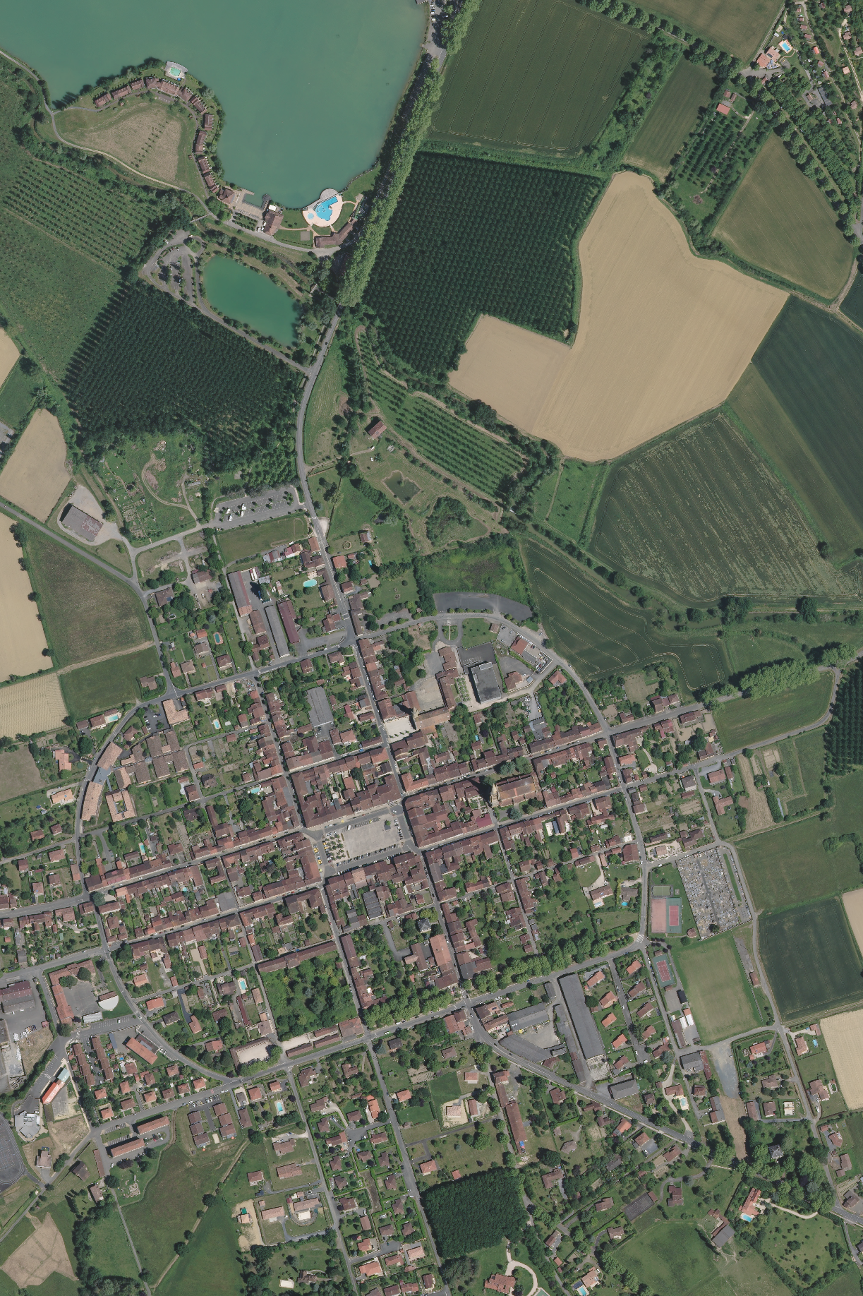
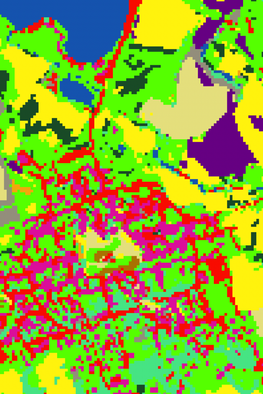
Inference
Aerial ROI
Inference ROI
Cite
BibTeX:
@article{ign2025flairhub,
  doi = {10.48550/arXiv.2506.07080},
  url = {https://arxiv.org/abs/2506.07080},
  author = {Garioud, Anatol and Giordano, Sébastien and David, Nicolas and Gonthier, Nicolas},
  title = {FLAIR-HUB: Large-scale Multimodal Dataset for Land Cover and Crop Mapping},
  publisher = {arXiv},
  year = {2025}
}
APA:
Anatol Garioud, Sébastien Giordano, Nicolas David, Nicolas Gonthier.
FLAIR-HUB: Large-scale Multimodal Dataset for Land Cover and Crop Mapping. (2025).
DOI: https://doi.org/10.48550/arXiv.2506.07080