

metadata
license: etalab-2.0
pipeline_tag: image-segmentation
tags:
  - semantic segmentation
  - pytorch
  - landcover
library_name: pytorch
model-index:
  - name: FLAIR-HUB_LC-F_swinbase-upernet
    results:
      - task:
          type: semantic-segmentation
        dataset:
          name: IGNF/FLAIR-HUB/
          type: earth-observation-dataset
        metrics:
          - type: mIoU
            value: 64.868
            name: mIoU
          - type: OA
            value: 77.685
            name: Overall Accuracy
          - type: IoU
            value: 84.002
            name: IoU building
          - type: IoU
            value: 79.283
            name: IoU greenhouse
          - type: IoU
            value: 61.59
            name: IoU swimming pool
          - type: IoU
            value: 75.611
            name: IoU impervious surface
          - type: IoU
            value: 57.694
            name: IoU pervious surface
          - type: IoU
            value: 63.826
            name: IoU bare soil
          - type: IoU
            value: 90.461
            name: IoU water
          - type: IoU
            value: 68.142
            name: IoU snow
          - type: IoU
            value: 54.871
            name: IoU herbaceous vegetation
          - type: IoU
            value: 56.893
            name: IoU agricultural land
          - type: IoU
            value: 37.914
            name: IoU plowed land
          - type: IoU
            value: 78.144
            name: IoU vineyard
          - type: IoU
            value: 71.731
            name: IoU deciduous
          - type: IoU
            value: 63.69
            name: IoU coniferous
          - type: IoU
            value: 29.627
            name: IoU brushwood
🌐 FLAIR-HUB Model Collection
- Trained on: FLAIR-HUB dataset 🔗
- Available modalities: Aerial images, SPOT images, Topographic info, Sentinel-2 yearly time-series, Sentinel-1 yearly time-series, Historical aerial images
- Encoders: ConvNeXTV2, Swin (Tiny, Small, Base, Large)
- Decoders: UNet, UPerNet
- Tasks: Land-cover mapping (LC), Crop-type mapping (LPIS)
- Class nomenclature: 15 classes for LC, 23 classes for LPIS
🔍 Model: FLAIR-HUB_LC-F_swinbase-upernet
- Encoder: swin_base_patch4_window12_384
- Decoder: upernet
- Metrics:
- Params.: 97.7
General Informations
- Contact: [email protected]
- Code repository: https://github.com/IGNF/FLAIR-HUB
- Paper: https://arxiv.org/abs/2506.07080
- Developed by: IGN
- Compute infrastructure:
- software: python, pytorch-lightning
- hardware: HPC/AI resources provided by GENCI-IDRIS
- License: Etalab 2.0
Training Config Hyperparameters
- Model architecture: swin_base_patch4_window12_384-upernet
- Optimizer: AdamW (betas=[0.9, 0.999], weight_decay=0.01)
- Learning rate: 5e-5
- Scheduler: one_cycle_lr (warmup_fraction=0.2)
- Epochs: 150
- Batch size: 5
- Seed: 2025
- Early stopping: patience 20, monitor val_miou (mode=max)
- Class weights:
    - default: 1.0
    - masked classes: [clear cut, ligneous, mixed, other] → weight = 0
- Input channels:
    - AERIAL_RGBI : [4,1,2]
    - SENTINEL2_TS: [1, 2, 3, 4, 5, 6, 7, 8, 9, 10]
    - SENTINEL1-ASC_TS: [1, 2]
    - SENTINEL1-DESC_TS: [1, 2]
- Input normalization (custom):
    - AERIAL_RGBI:
        mean: [106.59, 105.66, 111.35]
        std:  [39.78, 52.23, 45.62]
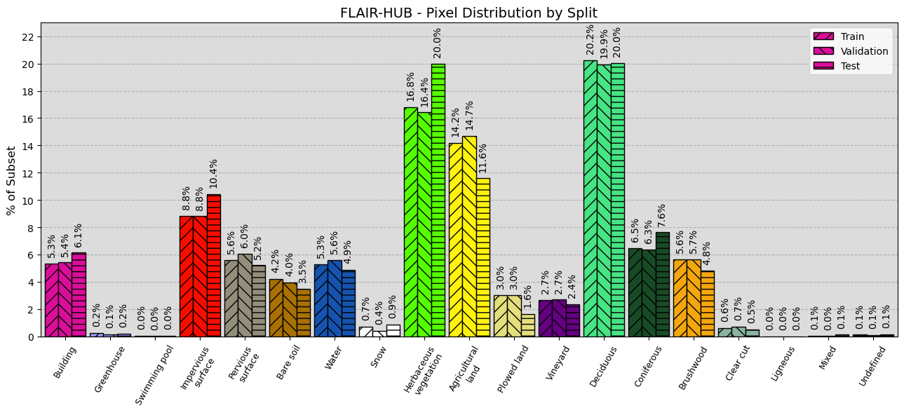
Training Data
- Train patches: 152225
- Validation patches: 38175
- Test patches: 50700
Training Logging
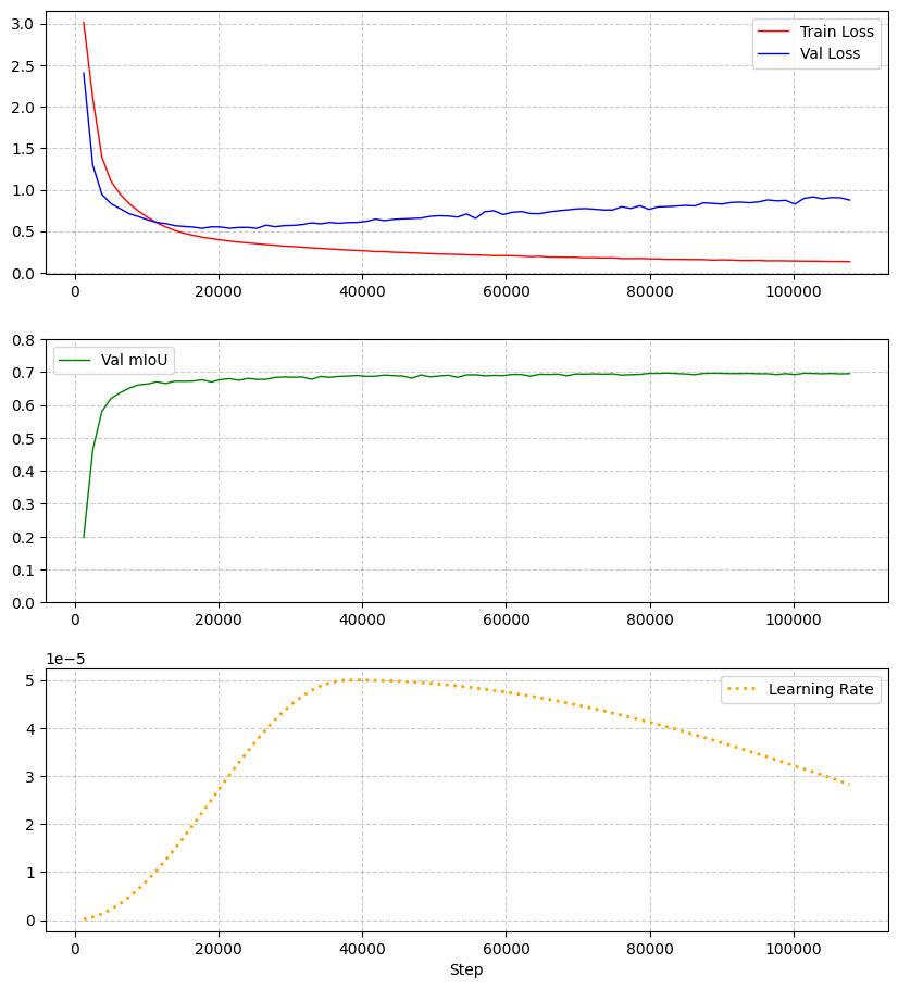
Metrics
| Metric | Value |
|---|---|
| mIoU | 64.87% |
| Overall Accuracy | 77.69% |
| F-score | 77.47% |
| Precision | 77.69% |
| Recall | 77.73% |
| Class | IoU (%) | F-score (%) | Precision (%) | Recall (%) |
|---|---|---|---|---|
| building | 84.00 | 91.31 | 90.86 | 91.76 |
| greenhouse | 79.28 | 88.44 | 85.63 | 91.45 |
| swimming pool | 61.13 | 75.88 | 73.91 | 77.95 |
| impervious surface | 75.61 | 86.11 | 87.53 | 84.74 |
| pervious surface | 57.69 | 73.17 | 71.90 | 74.49 |
| bare soil | 63.83 | 77.92 | 73.15 | 83.35 |
| water | 90.46 | 94.99 | 95.79 | 94.20 |
| snow | 68.14 | 81.05 | 96.94 | 69.64 |
| herbaceous vegetation | 54.87 | 70.86 | 71.99 | 69.77 |
| agricultural land | 56.89 | 72.52 | 70.36 | 74.82 |
| plowed land | 37.91 | 54.98 | 50.82 | 59.88 |
| vineyard | 78.14 | 87.73 | 85.52 | 90.05 |
| deciduous | 71.73 | 83.54 | 83.31 | 83.77 |
| coniferous | 63.69 | 77.82 | 77.95 | 77.68 |
| brushwood | 29.63 | 45.71 | 49.63 | 42.36 |
Inference
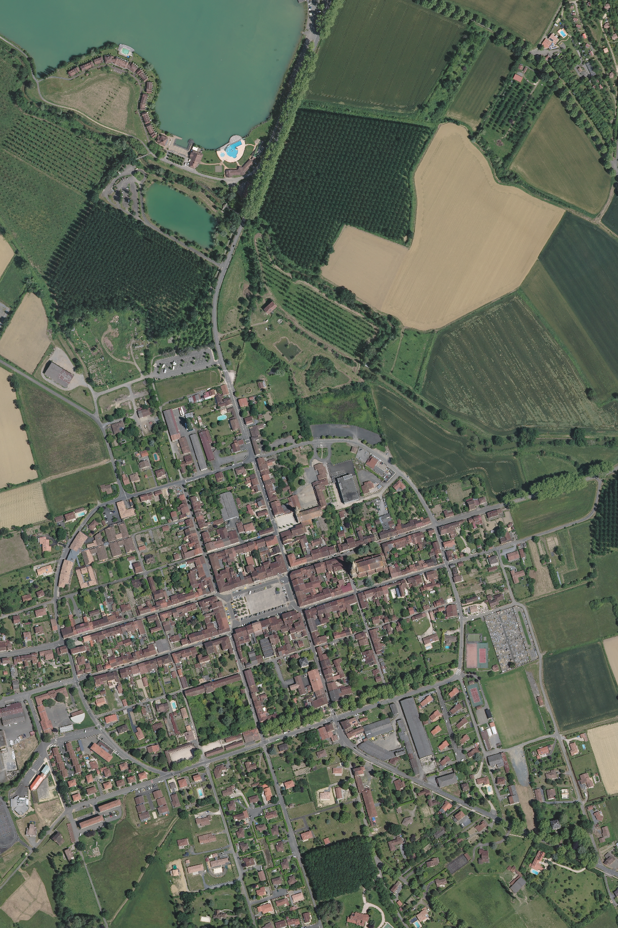
Aerial ROI
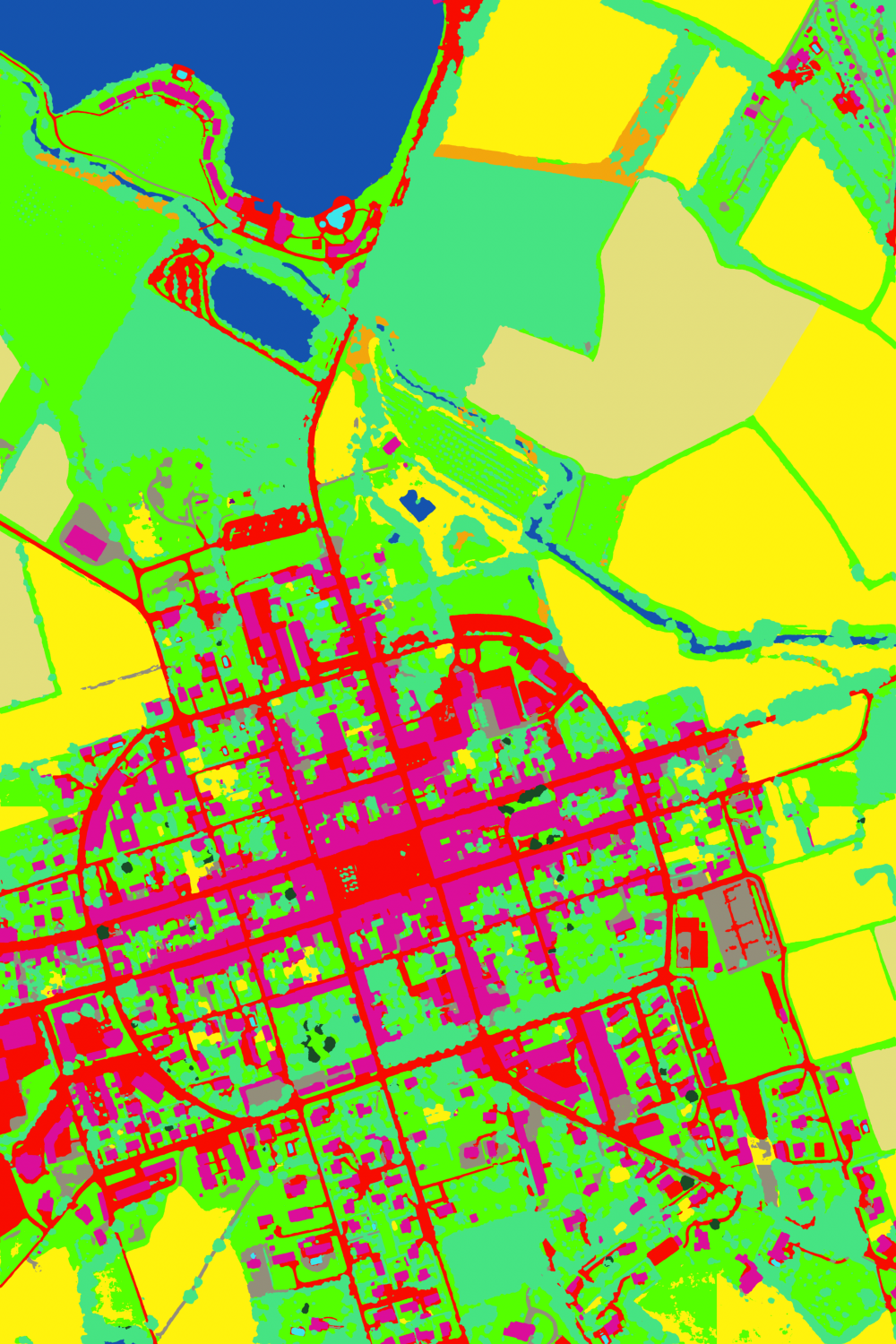
Inference ROI
Cite
BibTeX:
@article{ign2025flairhub,
  doi = {10.48550/arXiv.2506.07080},
  url = {https://arxiv.org/abs/2506.07080},
  author = {Garioud, Anatol and Giordano, Sébastien and David, Nicolas and Gonthier, Nicolas},
  title = {FLAIR-HUB: Large-scale Multimodal Dataset for Land Cover and Crop Mapping},
  publisher = {arXiv},
  year = {2025}
}
APA:
Anatol Garioud, Sébastien Giordano, Nicolas David, Nicolas Gonthier.
FLAIR-HUB: Large-scale Multimodal Dataset for Land Cover and Crop Mapping. (2025).
DOI: https://doi.org/10.48550/arXiv.2506.07080